
Did you know LiDAR technology was first used in the 1960s? Laser scanners were mounted to airplanes. Within mapping, remote sensing, imaging, mining, and geospatial fields, Lidar technology is used to create high-resolution models of ground elevation with vertical accuracy of 4 inches.
Integration of a combination of laser safe scans with GPS initiates an accurate method of calculating geospatial measurements. Lidar uses a pulsed laser to calculate an object’s variable distance from the earth’s surface. Below are a few insights about Lidar technology and how it works.
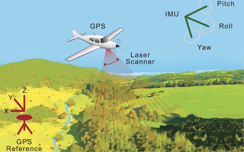
Primary components of LiDAR instrument
- Scanner
- Laser
- GPS receiver
- Photo-detector and optics
Types of LiDAR Systems
Airborne LiDAR
This type of Lidar system is installed on a drone or helicopter for data collection. The LiDar emits light toward the ground surface. The sensor receives the measurement details once the emitted light hits the object. Forms of airborne LiDAR include Topological Lidar and Bathymetric Lidar.
Terrestrial LiDar
Terrestrial LiDAR is a ground system that is installed on moving vehicles or tripods on the earth’s surface. They are used to collect valid data points. Terrestrial Lidar is commonly suited for observing highways, scrutinizing infrastructure, and collecting point clouds from both in and out of a building. Typical forms of terrestrial LiDAR include Static Lidar and Mobile Lidar.
How LiDAR technologies work
Lidar tech uses a standard principle in that the laser light emitted is thrown at an object on the earth’s surface. The time it takes to return to the LiDAR source is calculated and recorded. The speed at which the light travels is approximately 186,000 miles per second.
To measure and arrive at a precise distance through Lidar entails using a technical formula that; the distance equals to speed of light time of flight divided by two ( distance = speed of light X time of flight/2).
Developmental uses and application of LiDAR Technology
Land Surveying
Lidar sensors can be easily attached to drones for a quick, cost-effective, and accurate generation of 3D digital terrain models. Drones are faster and easier to deploy than helicopters, especially in specific land areas.
Oceanography
LiDAR technology enables the calculation of depth on the ocean surface for research purposes. More so, it eases the estimation of phytoplankton fluorescence and biomass in the ocean surface.
Transportation and expansion
Transportation infrastructure such as rail stations incorporates lidar technology to generate transit system data for future plans.
Power Line Inspection for maintenance
Lidar technology is used in identifying hurdles emerging from within power lines. Once Lidar determines the issue, companies can assess damage to devise a low-risk solution.
Mining applications
Lidar technology in the mining process cuts time, costs, and risk of exposure. Lidar calculates volumes of materials in open mines without disrupting groundwork.
Forestry and Farming
Drones are equipped with LiDAR systems and then deployed to survey large farms. Surveillance helps determine how resources can be used to increase productivity. Over forest cover, the Lidar systems penetrate to create 3D models that portray the impact of human activity.
Conclusion
Light detection and ranging is a popular remote sensing methods. Lidar measures the exact distance of an object on the earth’s surface. Most organizations use drones and helicopters to acquire Lidar data.